It depends on the setting for the type of map, what dialog box is displayed after clicking on this menu point. If you've choosen a "WMS server", you will get a dialog box where you can define everything to access the WMS server. If you've choosen a raster image type map, you'll get a dialog box, where you can define the corners of the map. In the following you will find descriptions for this dialogs.
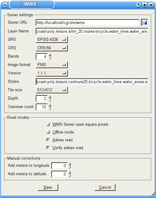
This dialog contains everything you may need to set, to control a WMS (WEB Map System) server. A WMS server uses the HTTP protocol to communicate. Therefore a map is requested in a similar way, like a normal home page. You can proof this with your favorite browser. Type in the following URL and watch what happens:
http://onearth.jpl.nasa.gov/wms.cgi?VERSION=1.1.1&REQUEST=GetMap&SRS=EPSG:4326&LAYERS=modis,global_mosaic&STYLES=&FORMAT=image/png&WIDTH=800&HEIGHT=600&BBOX=14.200104,46.612177,14.307995,46.633730Ther should appear a satelitte picture, showing a part of Klagenfurt,
the capital city of Kärnten, that is a county of Austria.
This example makes clear how easy it is to use a WMS server as a source for maps.
Because a static map wouldn't be useable, SportWatcher is able to handle
the control of a WMS server for you. All you need is to set some parameters.
Beside the WMS server shown in the example above, there are many more available in the internet. The page
http://www.skylab-mobilesystems.com/en/wms_serverlist.htmlprovides a list of free WMS servers all over the world.
This input line contains the URL of a WMS server. Applied to the example above,
this would be: http://onearth.jpl.nasa.gov/wms.cgi.
You don't need to provide extra parameters, because SportWatcher do this
for you in the background.
A WMS server may provide one or more layers. Such a layer often belong to a
specific part of the map. Think about a street map, for example. There, one layer
could contain the streets, another the rivers and another the labels. After
defining all three layers, it would be a complete map.
This input line contain the layers, separated by a comma. You should pay
attention to the order of the layers, because one layer is drawn above the other
in the given order (should streets be draw above the rivers, or reverse?)
To get a map with correct dimensions, the WMS server have to know the wanted geodetic date. If you want to learn more about geoids and projections, look at:
http://en.wikipedia.org/wiki/GeoidSportWatcher provides several geodetic dates. You must choose one, that is supported by the WMS server. Otherwise the map will not exactly fit under the tracks. In doubt take EPSG:4326, also known as WGS84.
CRS is mostly the same as SRS (look at 4.2.1.3). But this parameter is optional. In doubt, take WGS84.
A WMS server returns a raster image, representing the requested map. Every digital picture
consist of informations for every of the three color channels red, green and
blue. Such a channel is also called a band (because of the method the information
of the picture is managed internally). In case of a color picture, there are at least three
bands. However. Such a picture could contain a fourth band, called the alpha channel.
The alpha channels defines the transparency of every pixel of the picture.
It is important to set the correct number of bands, because you'll get an error if this
is set wrong!
There are more than one version of communication protocol for WMS servers. A WMS server should be backward compatible and should support version 1.1.0 at least. Today most of the WMS server support version 1.1.1. Only newer servers also support protocol version 1.3.0. In doubt set this to 1.1.1.
Beside the above mentioned layers (look at 4.2.1.2), styles are also supported. For most WMS servers styles are optional.
A style is a variant or part of a layer. One layer could consist, for example, of the styles country road, interstate road and highway. Every kind of street can be a style. This allows you to filter particular types of roads. But it's only allowed to give the name of one style per layer. Be carefull to define exactly the same number of stayles, as you've defined layers and pay attanten of the order of the styles. They must apperar in the same order like the layers (one style per layer).
To save band width, SportWatcher groups the map into several quadrats with
equal size. This tiles are stored on the disk in a temporary cache. If it some parts
can be reused later, SportWatcher will take them out of the cache rather than
downloading them again.
This setting allows to set the size of such a tile. The optimal size depends on the
WMS server. You may test this to find out what works fast.
Should be set to 2.
FIXME: Describe me!
Should be set to 10.
FIXME: Describe me!
In case you find a WMS server that is not able to calculate the projection correct, you can try to set this option.
If you set this option, SportWatcher will not try to get a map from a WMS server. It only looks into the local cache and if it finds a map there, it displays ist. Otherwise the track appears with a black background.
FIXME: Describe me!
FIXME: Describe me!
In case the map is moved a little in x direction, you can correct it here. Type in the number of meters, the map is moved.
In case the map is moved a little in y direction, you can correct it here. Type in the number of meters, the map is moved.
 |
4. Read data |  |
|
4.2.2 Image Coordinates | |
© 2006 − 2011 by Andreas Theofilu (theosys)

