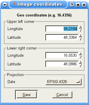
In case you've choosen a kind of raster display as your map, this dialog appears. Here you can set the corners in geographical format.
One drawback of raster formats is, that they contain no geographical information. To allow SportWatcher to use such raster images, it must know the dimensions of the map.
An even bigger drawback is the fixed resolution of the map. Depending of the magnifier, the map may look blurred or it looks coarse−grained. One benefit of such maps is, that they are available offline and they are faster than every vector format.
This defines the upper left corner. Define this values in the format of the set projection.
This defines the lower right corner. Define this values in the format of the set projection.
This setting defines the graphical projection of the map. Graphical projection is a protocol by which an image of an imaginary three−dimensional object is projected onto a planar surface without the aid of mathematical calculation. The projection is achieved by the use of imaginary "projectors". The projected, mental image becomes the technician's vision of the desired, finished picture. By following the protocol the technician may produce the envisioned picture on a planar surface such as drawing paper. The protocols provide a uniform imaging procedure among people trained in technical graphics (mechanical drawing, computer aided design, etc.).
SportWatcher allows to set some of the possible projections. Choose the one, used for your map.
 |
4.2 WMS settings |  |
|
5. Display a map underneath a track | |
© 2006 − 2011 by Andreas Theofilu (theosys)

